NEWTON ROAD LOOP

Hiking down the BPA Road with Mount Saint Helens in the distance.
Distance: 4.0 mile loop
Elevation Gain: 860 feet
Trailhead elevation: 100 feet
Trail high point: 920 feet
Season: all year
Best: all year
Pass: None needed
On the traditional lands of: the Stl’pulmsh (Cowlitz) people
Directions:
Drive north from Portland on US 30, St. Helens Road to the Linnton neighborhood.
Just past an intersection with NW Marina Way, 2.5 miles north of the St. Johns Bridge, look for a very small pullout on the left of the road immediately beneath some high-tension power lines.
Parking may be difficult but is possible on the other side of St. Helens Road.
Alternately, you may take Trimet bus #16 to a stop at the corner of NW St. Helens Road and NW Marina Way (Stop ID 10291). From here you’ll have to VERY CAREFULLY cross Saint Helens Road to find the trailhead. This used to be easier, but I cannot recommend it anymore. The trailhead is in a small roadcut beneath the power lines.
Drivetime from Portland: 15 minutes
Hike: This superb hike will make you forget at times you are in Forest Park, just minutes from a busy highway inside Portland city limits. You climb through a forested jungle to the dense woods on the Wildwood Trail. You will then descend a surprisingly beautiful powerline corridor that is spangled with wildflowers in summer. There is enough to see and do on this short trek that you will likely come back again and again, all throughout the year. This might be my favorite hike in the Portland area.

The Newton Creek Trail in late Spring.
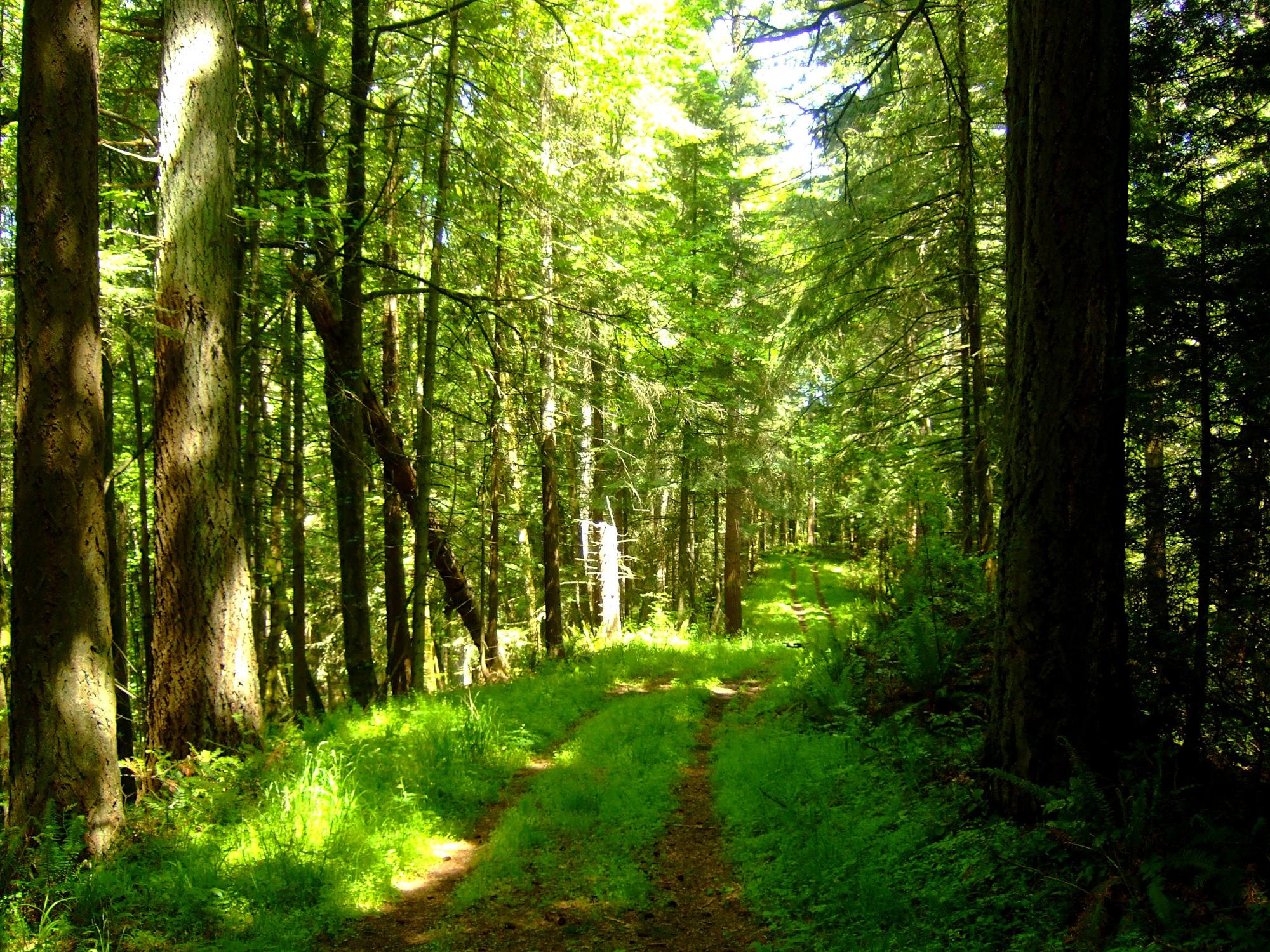
From a small gate next to St. Helens Road, you turn left on a rocky trail and almost immediately reach a fork. Turn left and hike on a narrow, somewhat overgrown trail that parallels St. Helens Road. While the road noise encroaches onto the trail, the forest is attractive. After a quarter mile the trail rounds a bend and enters Newton Creek’s steep, jungle canyon. Look for loads of salmonberries hanging over the trail in spring. Your senses are literally overwhelmed with green (for most of the year, at least) as you parallel a trickling creek to your left. This is one of the most attractive spots in all of Forest Park and virtually nobody knows of it. Sadly, you only have this canyon to enjoy for a quarter mile, after which you cross Newton Creek and begin climbing out of the canyon on an old roadbed.
Begin climbing into more attractive forest from here as you approach the Wildwood Trail. In summer look for oceans of orange tiger lilies on the sides of the road. The trail levels out and enters deeper forest, finally meeting the Wildwood at a well-traveled intersection 1.3 miles from the trailhead. If you have ever hiked the Wildwood Trail, you will not be surprised to see that this section is much like the rest of the Wildwood – wide and gradual and continually winding in and out of side canyons through attractive forest. Stay on this popular hiking and jogging path for 1.15 miles. Watch your step as this section of the Wildwood is particularly popular with spotted leopard slugs – don’t crush them!
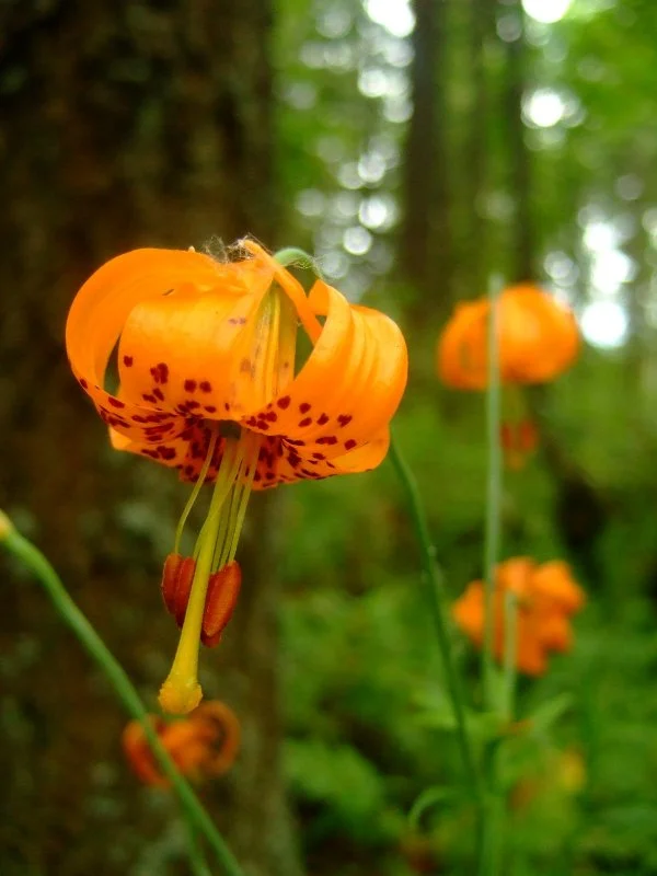
Tiger lilies along Newton Road
When you reach a set of high tension lines, round a bend and meet the BPA Road in a section of Forest Park known as Hole-In-The-Park. Turn right on this old road and travel through a deforested power line corridor. Normally such a place would not be attractive for hiking, but in fact the deforestation has brought in other attractions – copious amounts of wild raspberries, thimbleberries and salmonberries as well as even more copious amounts of wildflowers. Depending on the season, look for pink foxglove and fireweed, purple Oregon iris and red columbine, among others. Ignore a trail junction with Firelane 12 at 0.35 mile from the Wildwood. After 0.6 mile underneath the power lines, reach a trail junction that is not obvious. To return to your car (or bus stop), turn right; to explore more of this part of Forest Park, turn left and immediately reach an unexpected picnic area complete with two tables below two sets of power lines.
While the view is obstructed you can see down to the confluence of the Columbia and Willamette Rivers at Sauvie Island and across Vancouver, Washington to Mount Saint Helens and Mount Rainier. This is a great lunch spot despite the power lines. The road to your left goes nowhere and does not reach St. Helens Road, so return to the junction and turn left on BPA Road. You will switchback steeply 0.9 mile down to a reunion with the Newton Road Trail and your trailhead. The section of road just above the trailhead is in fact very steep, so trekking poles are recommended. If you came by bus, turn right and walk down St. Helens road about 150 feet to the nearest bus stop.
Other hiking options:
Remember the road leaving the picnic area to your left that goes nowhere? It does in fact, go nowhere. However, if you have some extra time, it is well worth the effort to follow this road for 0.3 mile downhill into a gorgeous, lush forest that seems to hang over the path like something out of The Hobbit. This is a particularly attractive setting on a foggy day in winter. When you reach a junction with Firelane 13A, turn around and hike back uphill towards the picnic area. You cannot descend any further without bushwhacking as both roads dead-end in small clearings ringed by tangles of blackberry bushes.
If you have any more time, you can add an additional loop through more attractive forest by connecting the Wildwood Trail and two firelanes with an intersection at Hole-In-The-Park. To add this loop, continue straight on the Wildwood past the junction with BPA Road another 0.9 mile to a junction with Firelane 15. Turn right and descend steeply 0.4 mile to a junction with Firelane 12, and turn right again for 0.5 mile on this wide former road to climb back up to the Hole-In-The-Park junction. Then turn left on BPA Road to finish the loop. This loop adds an additional 1.8 miles and 400 feet of elevation gain to your hike.
Firelane 13, the road to nowhere