The Hardest Cuts: Bachelor Mountain via Bruno Meadows

Mount Jefferson from Bachelor Mountain.
Distance: 7 miles out and back
Elevation Gain: 1,700 feet
Trailhead elevation: 4,331 feet
Trail high Point: 5,941 feet
Season: June – October
Best: June – July
Pass: none needed
On the traditional lands of:
Directions:
From Salem, drive OR 22 east approximately 49 miles to Detroit.
From Detroit, drive south 16 miles to Marion Forks.
Continue past Marion Forks another 1.5 miles to a junction with FR 2234 on your right. There isn’t really a sign so you’ll have to watch closely.
Turn right here and immediately cross the North Santiam River on a concrete bridge.
Continue uphill about 2.5 miles to a confusing junction with several side roads on your left at a curve. There are two side roads here, one of which has a gate.
Stay on the main road (FR 2234) here and drive another 0.5 mile to a junction with another side road on your left. This is the trailhead for the Bugaboo Ridge Trailhead.
Continue driving 2.9 miles on FR 2234 to the Bruno Meadows Trailhead on the left side of the road.
Drivetime from Salem: 2 hours
Hike: Bachelor Mountain is the highest point in the Old Cascades, and perhaps the best hike. There are three ways to approach the scenic summit, and all of them are worthwhile. My favorite is the long-forgotten Bruno Meadows Trail. This path climbs through ancient forest and passes a spectacular hanging meadow to a junction with the Bugaboo Ridge Trail, and then on to the rocky summit of Bachelor Mountain. As with all forgotten trails, expect a fare share of blowdown and brush. I assure you; it is worth it!
The trail begins on an old road. Before long, you’ll reach the signed Bruno Meadows Trail. Turn right here and follow this narrow path along the edge of an old clearcut. Rhododendrons bloom profusely here in June and early July. The trail skirts the old clearcut here and there, passing through a grove of magnificent ancient Douglas fir that appears to have been narrowly saved. You will begin climbing along the northwest slopes of Bachelor Mountain in dense forest. At a little under a mile from the trailhead, you will reach a junction with a spur trail that heads left. Mount Jefferson is visible through the trees. Follow this short spur to a most wonderful viewpoint! Here, at the edge of a rocky and dry cliff, you will find great profusions of July wildflowers and spectacular views east to Mount Jefferson and points south. The meadowy mountain in front of Mount Jefferson is Minto Mountain if you’re keeping track. Watch your step here, as it’s a long way down from the edge of this viewpoint. Back on the main trail, continue some 0.3 mile through spectacular wildflower meadows to a junction with the Bugaboo Ridge Trail in a meadow of chest-high bracken ferns at 1.7 miles from the trailhead. Turn right here to stay on the Bruno Meadows Trail.
The trail then climbs above this meadow amid fabulous June and July displays of larkspur and mariposa lilies to a spectacular ridge end, where views stretch south to the Three Sisters (and behind you, Mount Jefferson). Continue on this trail, passing in and out of meadows, to a junction with the Bachelor Mountain Trail in deep woods at 2.9 miles from the trailhead. Looking behind you, note the old Bruno Meadows Trail sign high up on the tree! Turn right here and climb 0.6 mile through the woods to the rocky summit of Bachelor Mountain at 5,943 feet. The view here is magnificent, covering the entirety of the Old Cascades and much of the high Cascades from Mount Hood to the Three Sisters and beyond. A lookout once stood here, as evidenced by the bent metal and broken glass strewn about the summit. Although this is a popular destination, you should be able to find an isolated corner to spread out for lunch.
Return the way you came, stopping for many photos and merriment along the way.
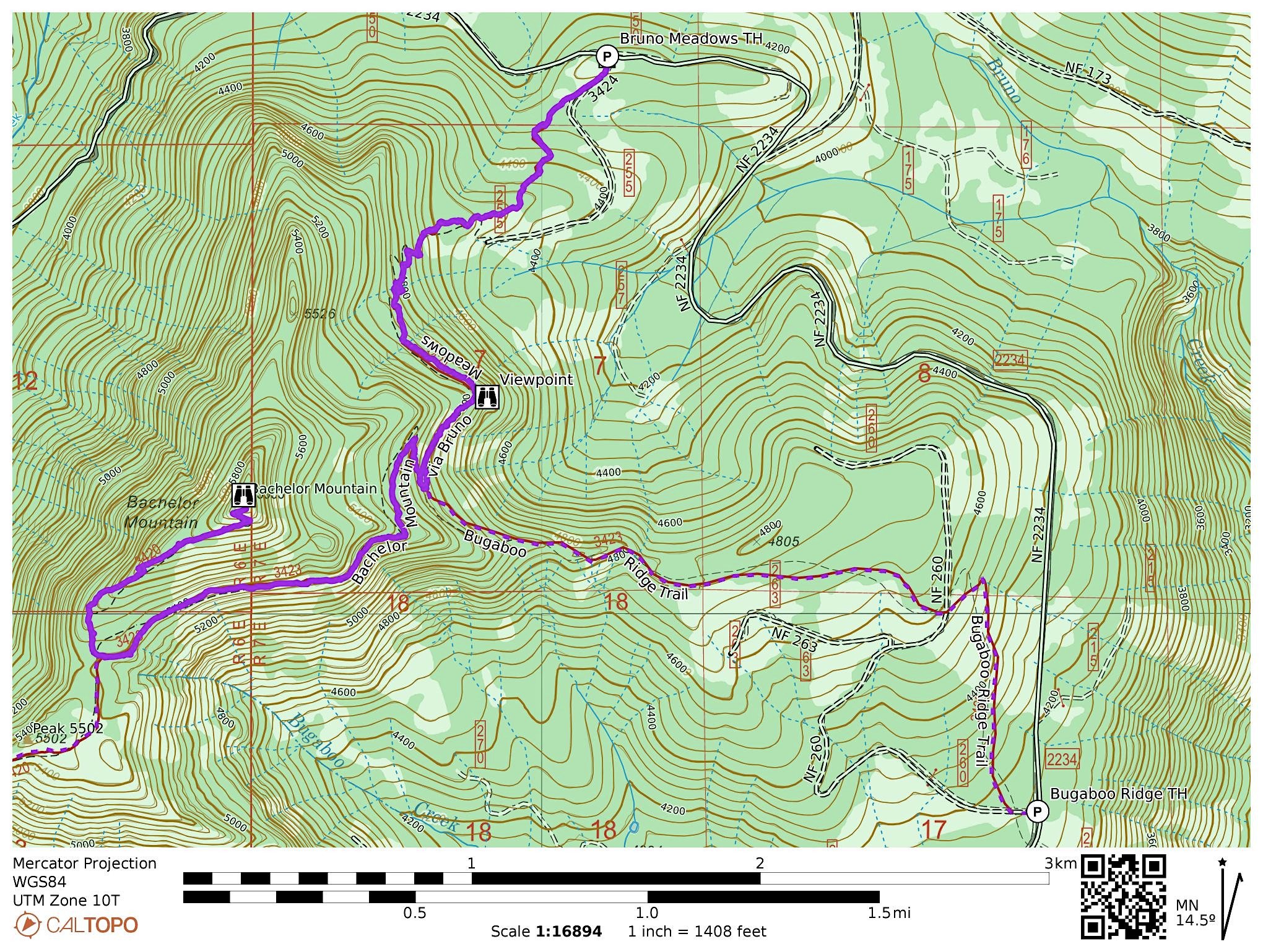
Map of the Bachelor Mountain via Bruno Meadows hike.