CHUSH FALLS

Chush Falls in the Three Sisters Wilderness was one of the hardest cuts.
Hike stats:
Distance: 6 miles out and back
Elevation Gain: 900 feet
Trailhead elevation: 4,633 feet
Trail high Point: 5,383 feet
Season: June – October
Best: June – October
Pass: none needed for day use
On the traditional lands of: the Warm Springs, Siletz, Grand Ronde, Cayuse, Umatilla, and Walla Walla peoples
Directions:
From Sisters, drive south on Elm Street, which becomes FR 16.
Drive 7.1 miles south from Sisters on this paved road to a junction with FR 1514 on your right. Note the sign for Whychus Creek. Turn right here.
Drive 4.8 miles of gravel road to a turn on your left with FR 600 just before a bridge over Whychus Creek. There is a sign for Chush Falls.
Turn left and drive 0.9 rocky miles to the signed trailhead at a turnaround. There is plenty of parking but be courteous to let other people find a place to park.
No permit is required for day use but should you wish to backpack you will need an overnight permit.
Drivetime: 30 minutes from Sisters
Hike: This fun trek to two spectacular waterfalls south of Sisters is an easy but surprisingly wild adventure. Beware hot days, however, as part of this hike is in terrain still recovering from the 2012 Pole Creek Fire, and the stretch of trail is quite hot and exposed. The chances are high that you won’t mind, as this is a gorgeous hike that you’ll find yourself returning to again and again!
From the marked trailhead, follow a wide trail cut through fields of snowbrush (Ceanothus). The Pole Creek Fire left behind scores of ghostly tree snags, but opened up views of the Three Sisters nearby. The snowbrush then grew in after the fire, as it so often does in Central Oregon. At about 1 mile from the trailhead, you will pass a shady spot with an excellent view of the Three Sisters as well as Broken Top. Whychus Creek rages below. On hot days, this makes for an excellent rest spot. Keen eyes can even spot Upper Chush Falls, just to the right of Broken Top.
From this point on the fire damage is less intense for the most part, and the trail begins to follow Whychus Creek more closely. There are some stately ponderosa pines that stand proud here, survivors of the burn. At 2.4 miles, the trail seems to end at a downed tree just above Chush Falls. A sign here reads “End of trail”. The view of the falls is underwhelming, to say the least. For a better view, duck under the large downed tree behind the sign and follow a steep user path down to the creek. The path is dusty and brutally steep at times, and there’s no harm turning around if you become uncomfortable. Should you make it down, Chush Falls spreads out before you, a curtain of water that widens across the rocks as it tumbles. This is a supremely impressive waterfall, one worthy of a long stop.
Whether you went down to the falls or not, you will certainly see the “end of trail” sign. The trail does not end, in fact. To find Upper Chush Falls (also known as Kaluwas Falls), pick up the trail behind a small downed log just beyond the supposed end of the trail. This occasionally steep path is very obvious, climbing 0.5 mile to the base of Upper Chush Falls. Along the way you’ll pass diminutive Middle Chush Falls and push through some brushy spots in the trail. When you reach the end of the trail, the 220-foot falls tumbles and careens through a scenic cliff face of reddish and purple rock. You can carefully pick you way further up paths to get closer to the falls, but the view does not improve for the most part. As you approach the falls, these user trails become crumbly and precarious. Why the Forest Service decided that this trail does not exist is beyond me! The falls are amazing and it’s only a half-mile from the supposed end of the trail. The user path between the two falls is wide, obvious for the most part, and almost impossible to lose. Maybe some day this trail will come into the light – but for now, it’s our secret.
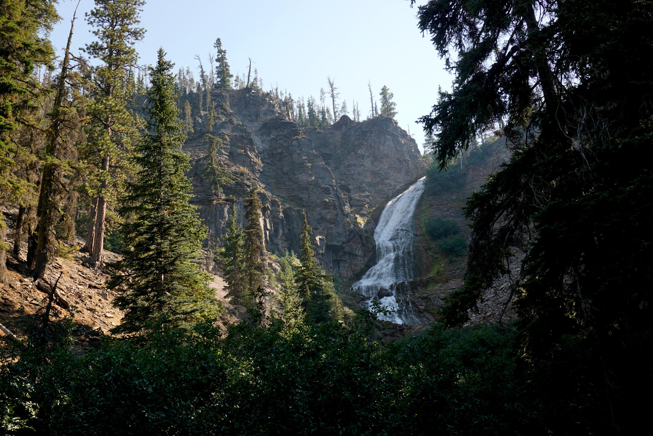
Upper Chush Falls (also known as Kaluwas Falls) in the Three Sisters Wilderness.
Return the way you came. Lovers of off-trail adventures can explore this area in search of more amazing waterfalls, but this is a trek best left to those capable of navigating off-trail up and down steep canyon slopes. If you’re curious, look elsewhere online for more information about the off-trail waterfalls in this area.

Map of the Chush Falls hike, with the locations of the other off-trail waterfalls in this area.