The Hardest Cuts: Devils Peak Lookout
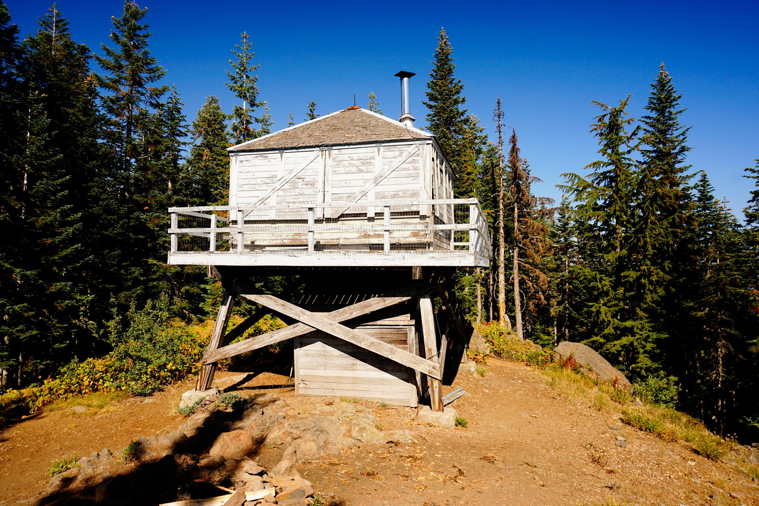
Devils Peak Lookout, October 2022.
Note: I finally hiked to Devils Peak Lookout in October 2022, many years after I first started hiking in this area. After the hike my wife and I determined that while it was not one of Oregon’s most extraordinary hikes, it was more than worthy of appearing in the second edition of PDX Hiking 365. Here is my entry from that book.
———————-
Distance: 8 miles out and back
Elevation Gain: 3,200 feet
Trailhead elevation: 1,852 feet
Trail High Point: 5,045 feet
Other seasons: June - November
Pass: None needed
On the traditional lands of: the Cascades and Molalla peoples
Directions:
From Portland drive southeast on US 26 for 35 miles to the small community of Welches.
Continue past the stop light and shopping complex in Welches another 2,4 miles on US 26 to a signed turnoff on the right for Still Creek Road.
Turn right here and drive 0.3 mile to a fork.
Keep right and drive 2.6 miles of narrow paved road and another 0.4 mile of potholed gravel to a pullout on the right signed for the Cool Creek Trail. This is the trailhead. There is plenty of room to park. The Cool Creek Trail begins at the sign.
Drivetime from Portland: 1 hour and 10 minutes
Why October: Beauty is in eye of the beholder, as the saying goes. While many hikers might shudder at the thought of gaining 3,200 feet in 4 miles to hike to a viewpoint that is merely good and not great, there is so much to love about this trek to Devils Peak’s abandoned fire lookout. This is a difficult hike for sure, but if you take your time. you’ll find much to love here. While this is not a fantastic fall color hike, the forest is beautiful on this slope and October’s cooler weather helps you keep from overheating on the hike up. The fire lookout that stands on the summit of Devils Peak is worth the effort, and you may even decide you want to stay the night on the summit here to take in the view of Mount Hood to the east.
Hike: The Cool Creek Trail does not mess around. The trail sets out from the trailhead and immediately begins climbing steeply out of Still Creek’s canyon. Pace yourself here, as you’ll gain 900 feet in the first mile, a pace that continues for the duration of this hike. Despite the trail’s name, Cool Creek is nowhere to be seen. The tall trees and thick rhododendrons help keep the trail cool on hot days, but there’s a reason I placed this hike in the October section of this book. At 1.3 miles, the trail reaches its first viewpoint of Mount Hood to the east, rising above the Zigzag River Valley. Stay on the trail and continue climbing steeply through the woods.
The Cool Creek Trail is definitely steep, but it does have the occasional gradual stretch. The trail mellows out a little at 2.7 miles, having already climbed 2,300 feet. From here, you’ll alternate stretches of steep trail with more gradual stretches. A short trail at 3.5 miles leads to the first truly excellent view of Mount Hood you’ll have on this trail. Don’t linger too long though, as you’re almost there! The Cool Creek Trail reaches a junction with the Hunchback Trail at 3.8 miles. Turn right and follow this trail for just 0.1 mile to a junction on the left with the spur trail to the lookout. Turn left here and follow this short trail to the summit of Devils Peak at 4 miles from the the trailhead. This is one of the more difficult hikes in this book, and you should feel proud for making it to the summit!
The star attraction of this hike is the abandoned lookout tower on the summit. The lookout was first constructed in the 1920s, only to fall into disrepair in the years that followed The lookout was reconstructed after World War II and staffed until 1964, at which point it was abandoned. Volunteers maintain this structure, and though it is officially closed to the public, a quick inspection of the lookout reveals that it does indeed see a great deal of use. The cupboards are frequently stocked with food and supplies, and you may even meet somebody staying here. If you decide to spend the night, keep your supplies in a bear canister as mice are known to inhabit the lookout. While trees have grown around the summit over the past fifty years, the view of Mount Hood is still excellent. Additional exploration around the summit area reveals views south to Mount Jefferson.
With such a difficult hike up comes the pain of leaving. I recommend bringing trekking poles on this hike to save your knees from the impact of the descent. The trail network along Hunchback Ridge offers many opportunities for further exploration, but it’s probably best to just return the way you came.

Map of the Devils Peak Lookout hike.