HAWK MOUNTAIN
Note: Before the fires in 2020 and 2021 the Hawk Mountain hike was one of most obscure and beautiful hikes in this part of the Cascades. This hike features in my books 101 Hikes in the Majestic Mount Jefferson Region and Off the Beaten Trail. I went back and hiked the trail in August 2023 on a cloudy with rain and thunderstorms in the area. The fires burned over parts of this trail but much of it remains unburned. The view on the other hand is now a long landscape of burned forest. The trail was recently maintained, the hike is still beautiful, and the historic cabin remains intact on the summit. I still love this hike, though. You probably will too!

The cabin on Hawk Mountain with its view of Mount Jefferson survived fires in 2020 and 2021.
Hawk Mountain stats
Distance: 4.4 miles out & back
Elevation Gain: 900 feet
Trailhead Elevation: 4,559 feet
Trail High Point: 5,270 feet
Season: June - October
Best: July (wildflower season)
Pass: none needed
GPS Track: August 2023
On the traditional lands of: the Molalla, Siletz, Grand Ronde, Cayuse, Umatilla, and Walla Walla peoples.
Directions:
From Salem, drive OR 22 east approximately 49 miles to Detroit.
Turn left at a sign for Breitenbush, Elk Lake and Olallie Lake onto FR 46.
Drive 16.6 miles on FR 46 to a pass where you enter the Mount Hood National Forest.
Continue another 0.6 mile to a junction with FR 6350, angling sharply away on your left.
If you are coming from Portland, this junction is exactly 28.1 miles from the Ripplebrook Guard Station on US 224. Keep a very close eye for FR 6350 on your right, which is very difficult to see if coming from the north.
Fork to the left on the wide gravel road and drive 4.7 miles to a four-way junction with FR 6355.
Turn left on this road for 0.3 mile to another junction with FR 150.
The trailhead is on your right at this junction but the best parking is down the side road to the left.
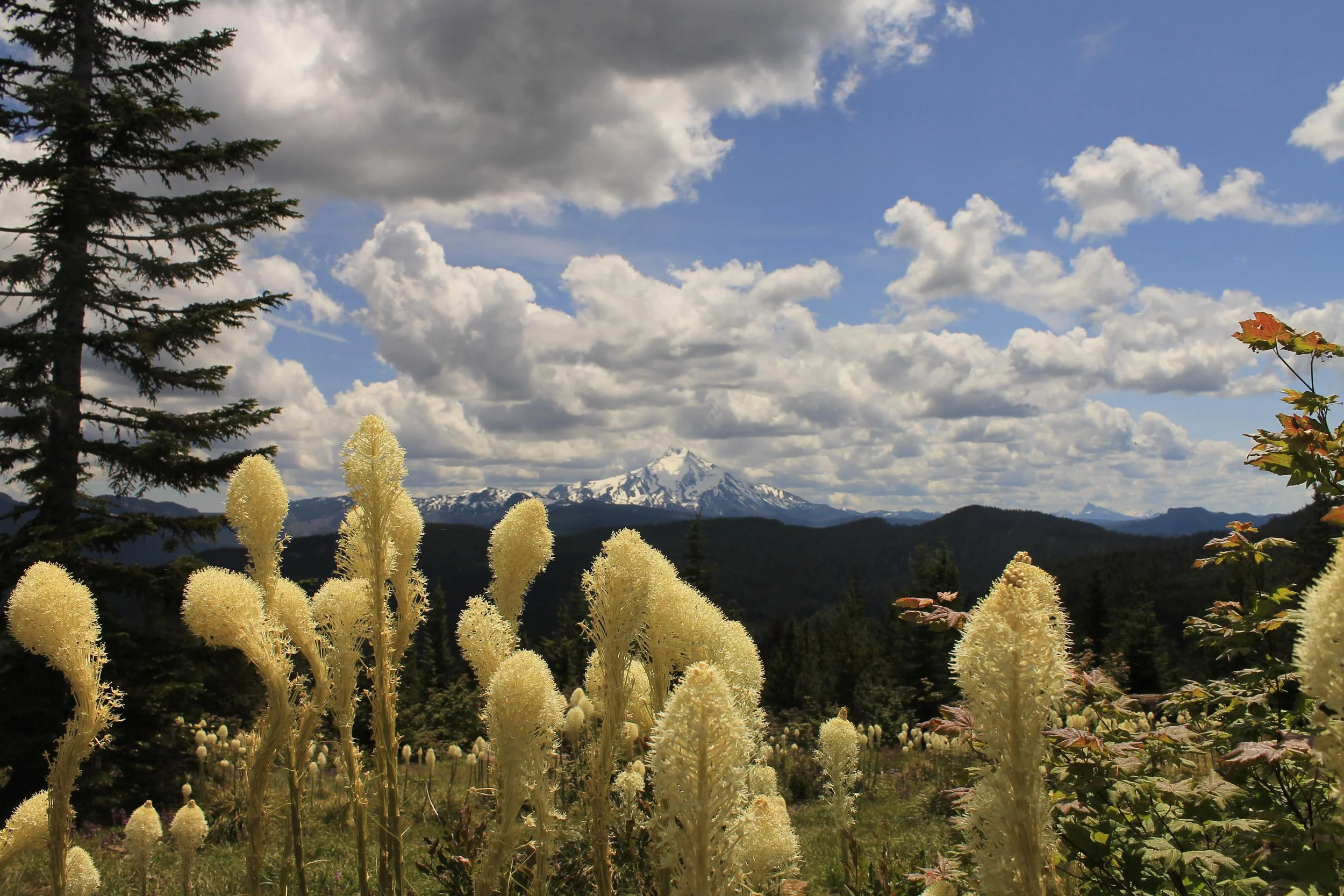
Beargrass on the summit of Hawk Mountain, June 2019

Lookout out the window of the cabin, June 2019
Hike: Hidden on a ridge top near Breitenbush Pass, Hawk Mountain features an outstanding view of Mount Jefferson to the south. A cabin remains where a lookout once stood, offering a fascinating look at the history of the area and a place to stay should you wish to spend the night. Wildflowers scent the mountaintop while butterflies light at your feet. In an area with many nice hikes, this is one of the nicest.
Begin by hiking through a meadow that is slowly becoming forested. This meadow is recovering from the 2021 fire but is still scenic. After only 100 yards look for a large clump of beautiful white-pink Cascade lilies in July; these showy flowers have a delightful perfume when fresh. The trail winds through this meadow for almost a half-mile, treating the hiker with more wildflowers and outstanding views of Mount Jefferson.

Mount Jefferson from the summit of Hawk Mountain, July 2010.
Here the trail is faint as beargrass is beginning to obscure the tread, but the way is never difficult. Switchback away from Mount Jefferson and climb slightly, entering forest 0.8 mile from the trailhead. Here descend into a lovely old-growth forest of mountain hemlock and silver fir and then begin climbing slightly again to make up what you just lost. Parts of this trail burned terribly during the fires, but you’re in fire damage for a short distance and then it’s back to unburned forest.
At 1.8 miles from the trailhead, reach a junction with the spur to the summit of Hawk Mountain at the edge of Round Meadow, a long, narrow meadow that serves as the headwaters to Round Lake two miles to the west. Turn right. On the spur, climb steadily through deep forest for 0.4 mile to the wide-open summit of Hawk Mountain, where you are greeted by its rustic lookout cabin, which survived the ravages of the two fires that burned through this area. The lookout tower that stood here was removed in 1967 but the recently-restored cabin remains. The staffers of the lookout stayed here and you may also stay in it if you wish to do so. As it is first-come, first-served, plan ahead and bring backpacking gear in case the cabin is occupied. In July the summit meadow is speckled with yellow arnica, red paintbrush, blue lupine and larkspur and white cat’s ears. Despite the fire damage, the view of Mount Jefferson to the southeast is even better than the flower display. This is a spectacular site! Return the way you came or arrange a car shuttle at the Graham Pass trailhead 5 miles to the north (see Other Hiking Options).
Other Hiking Options:
Round Lake: If you are in the area and wish to do a little more hiking, consider checking out Round Lake’s abandoned campground. While this suggestion may evoke thoughts of the Friday the 13th movie series, this is a nice place that sees very little use since the more direct approach to the lake washed out many years ago. The lake remains unburned, an island between the 2020 and 2021 fires.
To find the lake, follow FR 150 for 0.8 mile from the Hawk Mountain (Rho Ridge) Trailhead. Fork to the right (downhill) on FR 220 for 2 miles to a T junction with FR 6370. Turn right on FR 6370 and drive 3.5 miles to the signed trailhead on the right side of the road. The trail departs from a signboard and climbs to the lake. As you would expect for a former campground, there are several excellent campsites here. After the trail crosses an inlet creek it becomes very rough; you can continue around the lake on a rough and very brushy trail to make a 1.2 mile loop but it is much easier to return the way you came.
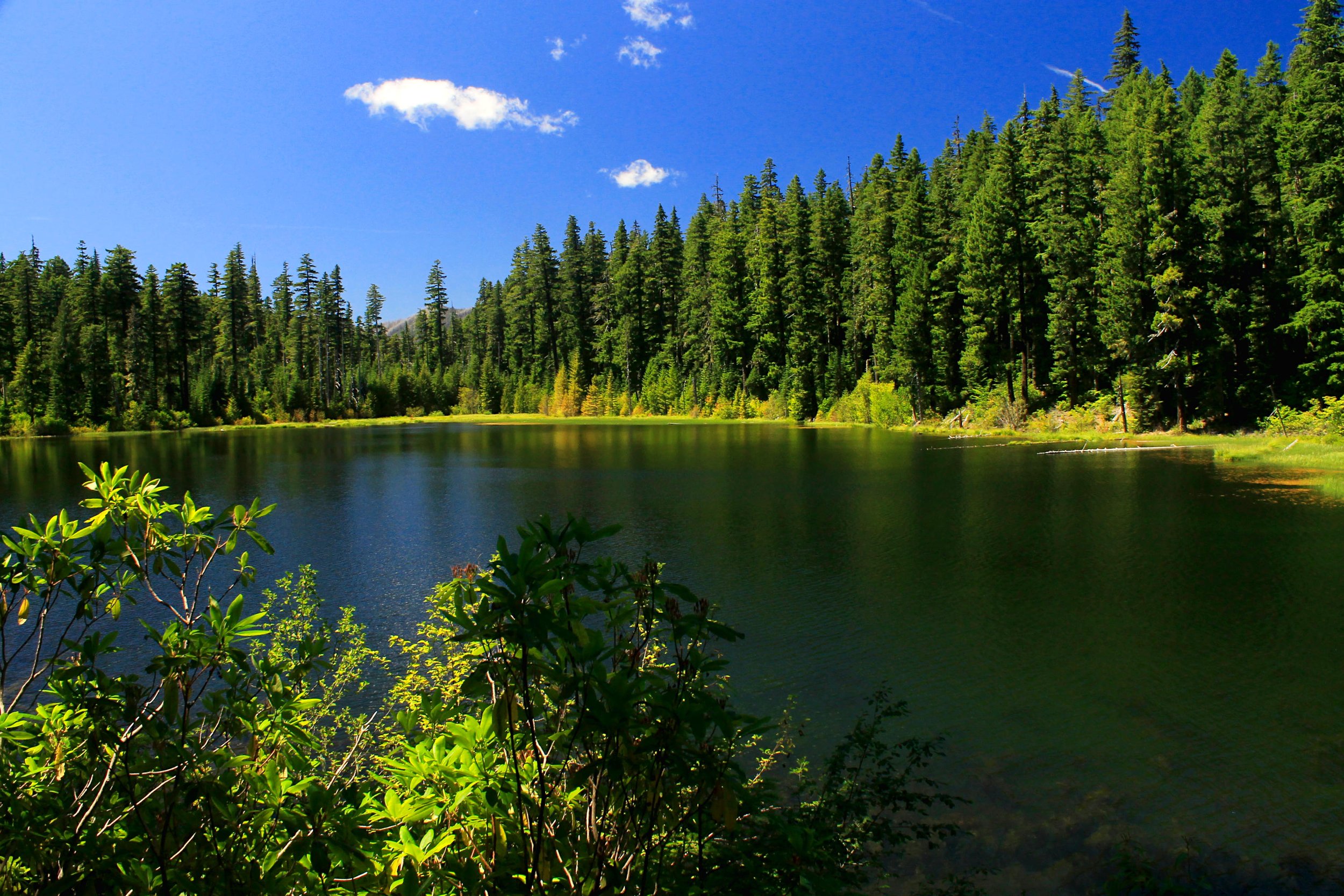
Round Lake, July 2014.
Hawk Mountain via Graham Pass: You may also hike to the summit of Hawk Mountain by way of the Rho Ridge Trail from Graham Pass. This approach is more than twice as long, has very few views and wanders through recovering clearcuts where the tread is frequently obscured by rhododendron and huckleberry. Though the tread is sometimes faint, yellow diamond-shaped signs that read “ULT 564” are posted on trees along the route to mark your way. You’ll also cross several decommissioned logging roads along the way, where in favorable years there are excellent displays of beargrass. You will reach the aforementioned junction with the Hawk Mountain spur trail at 4.8 miles from the trailhead, just after passing Round Meadow. Turn left here and hike uphill 0.4 mile to Hawk Mountain’s summit. This approach is 10.4 miles with 1,400 feet of elevation gain.
Directions to Graham Pass:
From Estacada, drive southeast on OR 224 for approximately 25 miles to the old guard station at Ripplebrook.
Just past Ripplebrook OR 224 becomes FR 46 at a junction with FR 57. Stay on the main road (ignore signs for Timothy Lake) and continue straight on FR 46 for 4.2 miles from Ripplebrook to a junction with FR 63, where you turn right, following signs for Bagby Hot Springs.
Drive 3.5 miles of pavement to a junction with FR 70, where you keep straight (ignore signs for Bagby Hot Springs).
Continue 5.1 miles on this road (it changes to gravel in 2.3 miles) to a junction with FR 6350 on your left.
Following a sign for Graham Pass, turn left onto paved FR 6350 and drive 5.6 miles of alternating gravel and pavement to a junction with FR 6355.
Fork to the left to stay on FR 6350 and continue 1 mile to Graham Pass.
Turn right into a large unsigned parking lot. This is the trailhead.
Note: There are two other ways to get here, both of which are fairly easy. The first involves driving FR 4670 from its junction on FR 46 for 14.3 miles to Graham Pass. The other involves driving FR 6350 from the Hawk Mountain Trailhead another 7.3 miles to Graham Pass. Either is a good way to get to Graham Pass, but the shortest route from Portland is the Collawash River approach described above. If you’re coming from Salem, you’ll want to drive to Hawk Mountain and follow FR 6350 to Graham Pass.
