After mostly taking a few years off from the Mount Jefferson area after the publication of 101 Hikes in the Majestic Mount Jefferson Region in 2016, I decided to go back and begin exploring the area again in 2019. I will be writing about some of these experiences here.
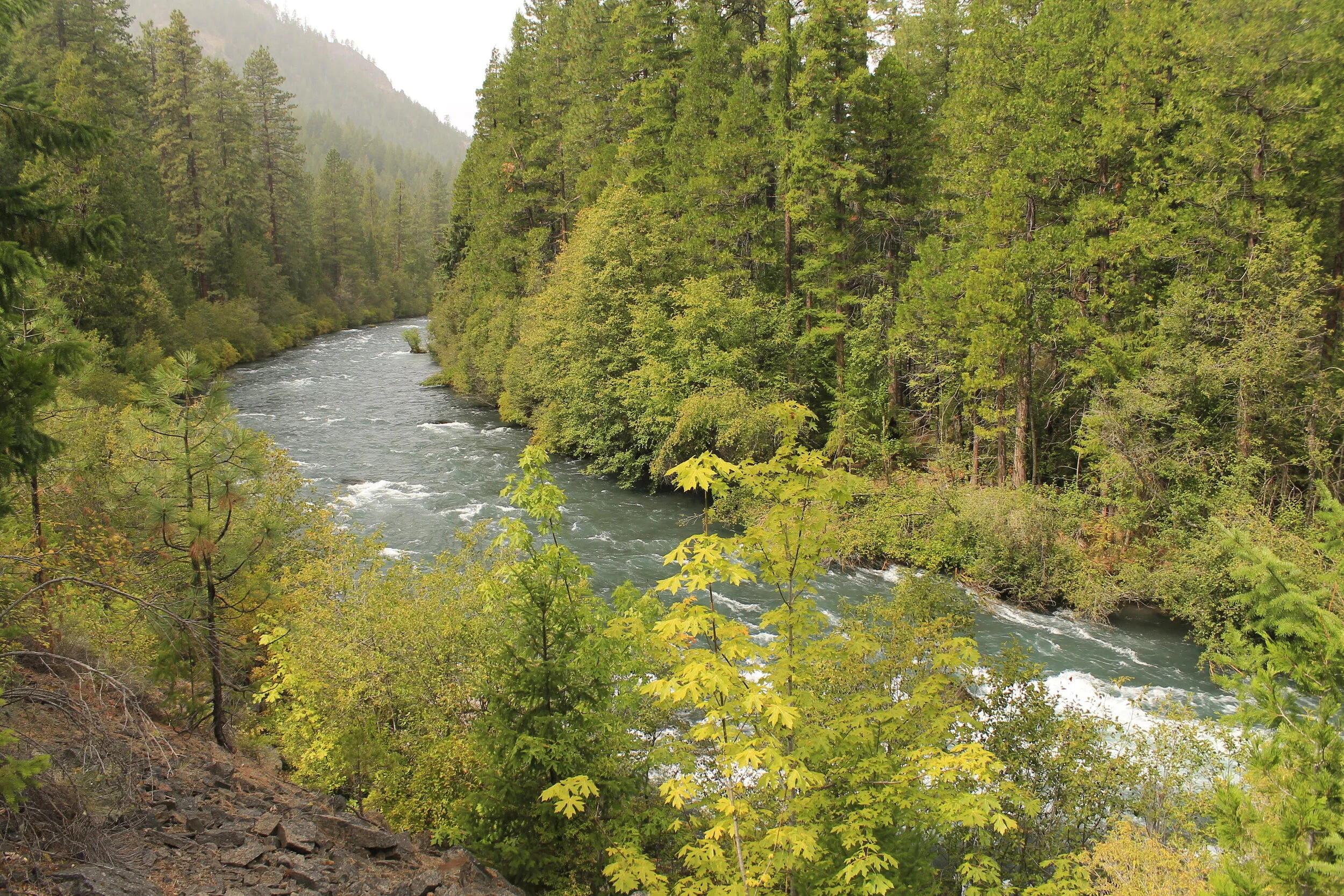
The Metolius River roars through its remote lower canyon.
Sometimes the best laid plans fall through at the last minute, and you’re left to figure out how to proceed. I should know better by now than to plan a mountain trip in September, but due to the peculiarities of my work schedule (long story short: I’m a community college professor, and we’re always off the first three weeks of September), September is when I have to explore. And like clockwork, every year when I plan a mountain trip in September, the rains come in to spoil my fun. To be fair, it doesn’t happen every year, but it’s happened enough for me to start to believe in such things as curses.
Anyway, I had planned a solo trip to Bend to explore the Three Sisters in September. The crux was to finally hike the Green Lakes Trail before the permit system takes hold. So of course, as soon as I had much of my trip planned, my head full of mountain dreams, the forecast came down calling for massive amounts of rain in the Cascades for the week of my trip. Nuts. It’s a good thing I’m pretty skilled at figuring out a backup plan.
It goes without saying that I love every square inch of the Majestic Mount Jefferson Region, but there are few places I love more than the Metolius River canyon. One of the more intriguing aspects of the Metolius canyon is that it’s the mirror opposite of most river canyons; while most mountain rivers flow out of a rugged wilderness into more-populous and less rugged valleys, the Metolius flows past cabins and campgrounds in its upper reaches into a rugged inner canyon that not many people take the time to see.
Looking at the forecasts was maddening, so I decided I to take my Bend trip day by day. For the first day of my trip, I figured that my best chance of staying dry was to hike into the inner canyon of the Metolius, which is located deep in the rain shadow created by Mount Jefferson. It turns out that I chose wisely…well, for the most part.
The day began with the long drive over Mount Hood and into central Oregon. Once I reached Madras, I followed signs to Cove Palisades State Park, where I had a cabin reserved for the evening. From there, I drove west along the Metolius Arm of Lake Billy Chinook until I reached the remote south side of Lake Billy Chinook. Eventually I reached the unmarked trailhead for Balancing Rocks, a natural rock formation on the south side of Lake Billy Chinook that was uncovered in a fire.

Balancing Rocks, September 2019.
From there, I continued driving along the Metolius Arm until I reached what was said to be a rough stretch of gravel road. It turns out the road was not as bad as expected - a pleasant surprise! It was rocky, yes - but nothing my Impreza couldn’t handle.
I finally arrived at Monty Campground sometime late in the morning. After so much driving it was nice to finally see the Metolius River and not just Lake Billy Chinook. The trailhead for the Lower Metolius River Road is just beyond Monty; continue driving on the dirt road past the campground until you see a gate. Park near the gate, but don’t block it. I packed up my gear and set off following the road, not really knowing what to expect. My planned goal was to hike the road to the Shut-In Trail, the rough trail that connects the two disconnected roads that follow the Metolius through its inner canyon.
Not far past the trailhead, I came to a fantastic view of the river:

The Metolius River near Monty Campground.
From there, I followed a wide trail down to river level. The trail took me along the Metolius for at least a half-mile before dead-ending, forcing me to scramble back to the gated road to continue my hike.
Now, about that gated road: some roads are wildly scenic, and some are fun walks; this one was neither. Much of my hike along the road looked like this:

The Lower Metolius River Road.
At one point I passed some private property, where I could hear the sound of construction equipment. The road avoids the Metolius for a stretch of at least two miles, and I began to get discouraged. But it wasn’t raining, and I was enjoying myself in spite of the boring hike.
After about 3.5 miles, the road drops back to the river, arriving at a spectacular viewpoint of the Metolius:

This spot was so beautiful I seriously contemplated declaring victory and turning around here. It was around this time that it started to rain, and I sat there thinking it might be a good idea to just turn around. So I sat on a rock, mesmerized by the colors of the Metolius below:

The rain passed after only a few minutes, and the sun came out, and so I decided to keep going until road’s end…and possibly beyond. I felt good, and up to this point the weather was better than expected. Looking at the map, I figured road’s end wasn’t very far away.
Not long after this viewpoint, I indeed came to road’s end. The road just…ends. Here, I saw a trail diving down the road bank to the right, towards the river bank. This was the Shut-In Trail. So I kept going.
The trail follows the Metolius River closely for much of its length. I was expecting the trail to be brushy, but I always keep clippers and a saw in my bag. I ended up not needing either much, at least for a while. Most of the trail was very scenic, and stayed close to the river.
Not far past road’s end, you come to a viewpoint of the Whitewater River where it flows into the Metolius:

The confluence of the Whitewater River with the Metolius River.
It didn’t take long to see why it is called the Whitewater River. The source of the river is the Whitewater Glacier on Mount Jefferson, some 10 miles to the west. The river flows through a remote part of the Warm Springs Reservation (the Metolius forms the southern boundary of the reservation for a considerable distance), down from Mount Jefferson and into the Metolius. The color comes from glacial silt, a common trait of glacier-fed streams. Just downstream of here I had noticed how the Metolius River seemed to be split in two, with one side white and the other blue:

Much to my surprise, the stretch of trail above the Whitewater confluence was in good shape, and the river surprisingly mellow through here. So I kept going, and going…and going. I had read before my trip that the Shut-In Trail was 1.5 miles long. When I passed 1.5 miles, I wondered when it would end. It turns out it was more like 2.5 miles. This last mile was in worse shape, and I started to wonder if I had made a huge mistake. By this point it was well into the afternoon, I was by myself and 7 miles from a remote trailhead deep in a remote canyon. But I kept going…and eventually, I stumbled upon a series of campsites. At the last of these, I came upon maybe the most surprising thing I’ve ever encountered on a hike deep in the wilderness:

Yes indeed: that is an apple. There was an apple tree here, completely loaded with little green apples:

It dawned on me that this must be a homestead site. It turns out I was right! I went home and looked through my maps. After exhausting the official maps, I pulled out my Metsker maps (a series of hand-drawn maps that were sold in Oregon in the 80s and 90s) and sure enough, I came across a reference to a homestead:

If you look closely at that map, you can see a reference to “Smith Cabin Historical Site”. I’ve spent awhile researching more information on this, and I’ve found nothing. At any rate, I took an apple and ate it. It was absolutely delicious.
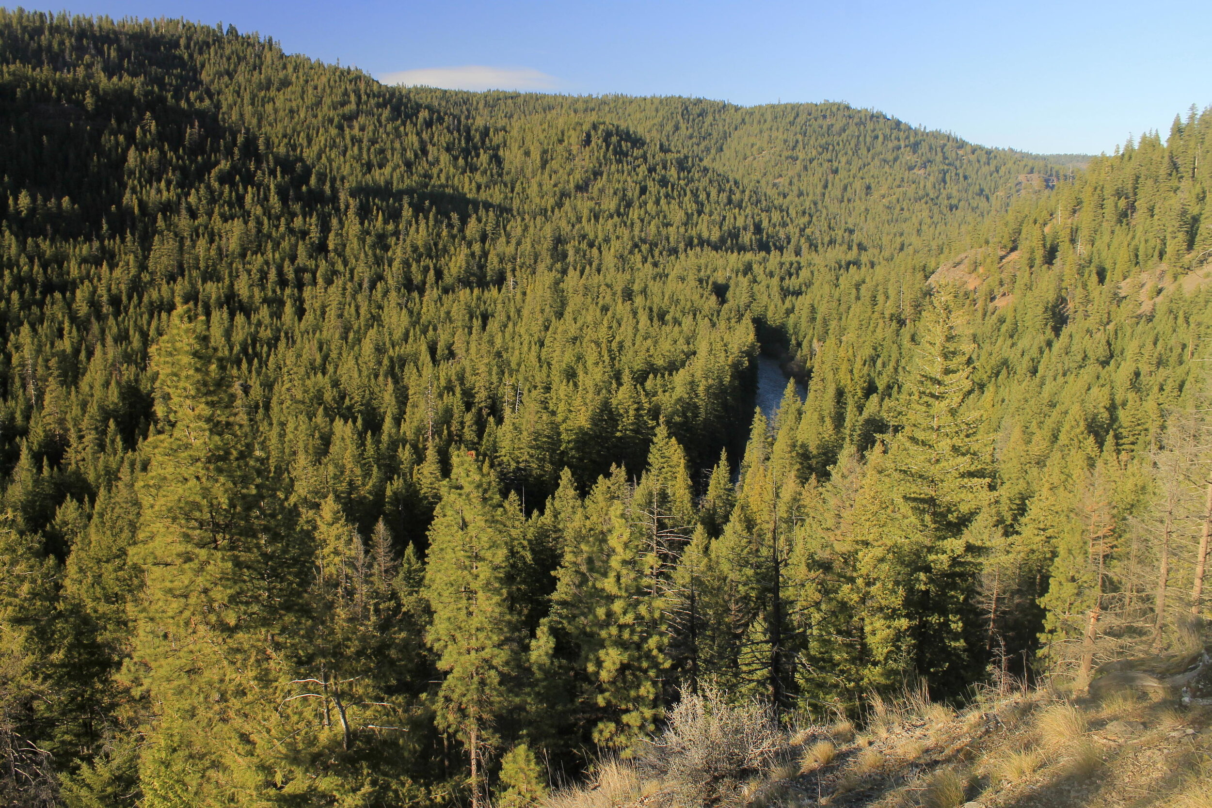
At this point, I figured I must be close to the end of the Shut-In Trail, so I kept going. After just a few more minutes, the terrain began to look familiar. I’ve been to this end of the Shut-In Before. In 2015, my buddy Karl and I backpacked along this end of the Lower Metolius during Spring Break. We hiked from Lower Bridge to this end of the Shut-In, before camping about 6 miles downriver from Lower Bridge. We did a lot of exploring on this trip. Among other things, we were looking for a fabled rock pinnacle known as the Shepard Tower of the Metolius. We never found it, but we did find this excellent viewpoint of the Metolius Canyon:
Karl and I had to turn around at the Shut-In Trail, so we never made it any further downriver. So at last, after four and a half years, I had hiked through the entire inner canyon of the Metolius!
I turned around here and made my way downriver, along the Shut-In Trail towards the lower trailhead. Along the way back I decided to do some trail maintenance, clipping out some brush and sawing out a few small logs. Most of the trail looked like this:

The Shut-In Trail.
While I was hiking my return trip along the Shut-In, it began to get dark. Very dark. Still, I continued doing my part to maintain the Shut-In to the best of my abilities.
There is one really neat spot near the eastern end of the Shut-In, where the trail passes directly next to the river:

This is a dramatic spot! The river is right there, flowing almost over the trail. I wonder if this spot floods? I have heard the Metolius never floods, but even so, one would think the river would occasionally wash over this spot. At any rate, it’s neat to be this close to the river.
Not long after, I left the Shut-In Trail behind and hiked up to the road again, where I had 4 miles of mostly boring hiking back to my car. Along the way the skies finally opened, and I hiked the last few miles back to my car in a pouring rain. I wasn’t even that upset! After all, I had enjoyed a fun and fascinating day up to this point. Given the forecast, it was as good as I could have expected.
It absolutely dumped rain on my drive back to Cove Palisades. I was very grateful to have a cabin for the night, as it ended up raining all night. But listen: I managed to get a full day of hiking in one of my favorite places, without getting rained on until the boring part of my day. Given the circumstances, I could not possibly ask for more. Now, about that rainy weather in September…hopefully this year will be different. I am sure I say this ever year!
Hike distance: 14.4 miles out and back
Elevation gain: 1,155 feet
Drivetime from Portland: longer than it looks
Attached below is a map of my hike. The road portion of the hike is marked in purple, the Shut-In Trail is marked in hot pink, and the route of my 2015 backpacking trip with Karl is marked in orange. Also marked are the various landmarks referenced in this post. This is such a fascinating area…there is always more to explore!
